
The newly identified sites
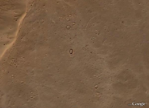
Fig. 3: SA3_499 – a deserted village centred around a possible mosque (with a mihrab in its west wall) - © ASAGE-Project
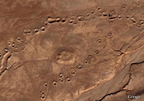
Fig. 4: SA2_101 – a fortified tepe with more recent lines of karez spoil heaps - © ASAGE-Project
Stratigraphy can be used as a way of dating sites in relative terms – some of the lines of karez spoil heaps, for example, overlap each other, and overlie (and thus post-date) other sites. The degree of sedimentation visible is another general indicator of age – older sites are more likely to have been affected by the build-up of wind-blown sands, although the type of site is obviously important – the standing remains of the 800 year old fortress of Qal’a-i Hauz are much less affected by aeolian deposition than the reservoir beside it.
Historical sources provide further indirect evidence to date human activity in the region – reconnaissance for the British Indian Army in the late nineteenth century noted extensive nomad activity in the Arghandab valley to the north of the Registan (Adamec 1980: 397), so it is probable that some sites date to this period. Prior to this, Ghaznavid sources and the string of medieval archaeological sites along the nearby river valleys demonstrate that the region flourished during the eleventh and twelfth centuries, so it is not unreasonable to suggest that other sites we have identified date to this period.
For the purposes of our study, we are following Waechter et al. (2006) in defining 1960 as the arbitrary division between ‘archaeological’ sites and ‘modern’ sites. This increases the value of the older satellite images such as the CORONA series – if the sites we have identified from the Google Earth satellite images appear in the CORONA images, we can demonstrate that they are pre-modern (i.e. pre-date the 1960s).
The next stage of the project will be to analyse the distribution of the sites found in the Registan, and to compare these data with the sites we are currently identifying in high resolution images in the mountains of Ghur province. This will enable us to address the methodological issue of whether Google Earth images can yield archaeological data in other environmental zones and to compare nomads’ utilisation of different landscapes.
References
Adamec, L.W. (ed.), 1980. Kandahar and south-central Afghanistan. Historical and political gazetteer of Afghanistan. Graz, Akademische Druck - u. Verlagsanstalt (ADEVA).
Ball, W., (1982). Archaeological gazetteer of Afghanistan. Paris, Editions Recherche sur les civilisations.
Balsan, F., 1972a. Au Registan inexplore (Sud-Afghan). Paris, Berger-Levrault.
Balsan, F., 1972b. Exploring the Registan desert, Asian Affairs: Journal of the Royal Central Asian Society 59 (n.s. III) (2): 153-156.
Beck, A., 2006. Google Earth and World Wind: remote sensing for the masses? Antiquity online 80 (308), available from http://antiquity.ac.uk/ProjGall/beck/ .
Beck, A., G. Philip, M. Abdulkarim and D. Donoghue, 2007. Evaluation of Corona and Ikonos high resolution satellite imagery for archaeological prospection in western Syria, Antiquity 81 (311): 161-175.
Bernard, P., 1982. An Ancient Greek City in Central Asia, Scientific American, (January 1982), 148-159.
Fischer, K., 1983. Archäologische Arbeiten über Afghanistan 1979-1982 und Studien zur historischen Topographie einiger Feldzüge von Alexander dem Grossen bis zur Gegenwart, Deutsches Orient-Institut, Mitteilungen 22: 47-69.
Fischer, K., D. Morgenstern and V. Thewalt (eds.), 1974-76. Nimruz. Geländebegehungen in Seistan 1955-1973 und die Aufnahme von Dewal-i Khodaydad 1970. Bonn, Rudolf Habelt Verlag.
Fleming, N., 2008. Google Earth reveals Afghanistan's hidden treasures, New Scientist 2665: 23.
Goossens, R., A. De Wulf, J. Bourgeois, W. Gheyle and T. Willems, 2006. Satellite imagery and archaeology: the example of CORONA in the Altai Mountains, Journal of Archaeological Science 33 (6): 745-755.
Hackin, J., 1959. ‘Recherches archéologiques dans la partie Afghane du Seistan. Diverses recherches archéologiques en Afghanistan (1933-1940)’, in J. Hackin, J. Carl and J. Meuné, Diverses recherches archeologiques en Afghanistan (1933-1940). Paris, Mémoires de la Délégation Archéologique Française en Afghanistan VIII: 23-37.
Handwerk, B., 2006. Google Earth, satellite maps boost armchair archaeology, National Geographic News online available from http://news.nationalgeographic.com/news/pf/28760948.html ..
James, N., 2007. Dazzled at Afghanistan’s cross-roads, Antiquity 81 (312): 435-437.
McCamish, T., 2008. The greatest earth on show, The Sunday Age, Melbourne 7/9/2008: 13.
Petrie, C.A., 2008. Remote sensing in inaccessible lands: plains and preservation along old routes between Pakistan and Afghanistan. ArchAtlas available from http://www.archatlas.org/workshop/Petrie07.php .
Philip, G., D. Donoghue, A. Beck and N. Galiatsatos, 2002. CORONA satellite photography: an archaeological application from the Middle East, Antiquity 76 (291): 109-118.
Schlumberger, D., 1978. Lashkari Bazar: une residence royale ghaznevide et ghoride. Paris, Diffusion de Boccard.
Thomas, D.C., F.J. Kidd, S. Nikolovski and C. Zipfel, 2008. The Archaeological Sites of Afghanistan in Google Earth, AARGnews 37 (September): 22-30.
Thomas, D.C. and C. Zipfel, 2008. A new look at Bust: Google Earth™ and archaeological sites in Afghanistan, poster presented at the Sixth World Archaeological Congress in Dublin, available from http://www.wac6.org/livesite/posters/poster_files/WAC_065_Thomas_Zipfel.pdf .
Ullmann, L. and Y. Gorokhovich, 2006. Google Earth and some practical applications for the field of archaeology, CSA Newsletter 18 (3), available from http://csanet.org/newsletter/winter06/nlw0604.html .
Ur, J., 2003. CORONA satellite photography and ancient road networks: a northern Mesopotamian case study, Antiquity 77 (295): 102-115.
Ur, J., 2006. Google earth and archaeology, The SAA Archaeological Record 6 (3): 35-38.
Waechter, S.A., J. Marvin and D. Foster, 2006. How old is "old"? Recognizing historical sites and artifacts. Sacramento, CA, CDF.
Zorich, Z., 2008. Afghanistan’s secret treasure, Archaeology 61(5), available from http://www.archaeology.org/0809/abstracts/afghanistan.html .
© ASAGE-Project - David C. Thomas, Claudia Zipfel, Fiona J. Kidd und Suzanna Nikolovski