
Brief History of Researches in Margiana
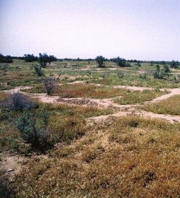
Spring 2003. The AK9 site before excavation.
If we leave on one side the adventurous excavations carried out at the beginning of the last century by a mission from the Carnegie Institute and led by Raphael Pumpelly regarding a Margian settlement from the I millennium BC, the real start of archaeological research in the region of the lower Murghab can be dated to 1946, with the setting up of the IUTAKE (Archaeological Expedition Complex in South Turkmenistan), under whose aegis between 1954 and 1956, the first excavations by M.E.Masson in the Delta area took place. There followed a long period of silence.
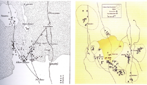
Margian Bronze Age sites according to Masimov (1979) and also Sarianidi (1990).
At the beginning of the seventies, discoveries made in northern Afghanistan and in the south of Uzbekistan reawakened the interest of a new generation of archaeologists in southern Turkmenistan. In 1972 the Margiana Archaeological Expedition (MAE) was set up by the Soviet Academy of Sciences and in the same year reconnaissance was carried out in the settlements of Auchin-depe and Takhirbai. Two years later, the Socialist Republic of Turkmenistan decided to promote its own archaeological researches and organised a special team from the Historical Institute "S. Batyrov" under the direction of Iminjan S. Masimov who, between 1975 and 1976, identified a new group of Bronze Age settlements of considerable size in a triangle between Takir Kelleli, Adji-Kui and AdamBassan (MASIMOV e LYAPIN: 1977). It is obvious that these researches stimulated many questions about the nature and distribution of prehistoric Margian settlements, and answers were sought by elaborating the data in their possession and advancing the first theories. The first attempt was made in 1981 hy Masimov, who divided the sites into three categories, on the basis of their size: 1) less than 5 hectares; 2) from S to 10 hectares; 3) more than 10 hectares.
One isolated piece of data stands out: the "Gonur case ", whose area exceeded 40 hectares, according to an estimate made by V. Sarianidi as reported by Ph. Kohl (1984: 146). This led Sarianidi to propose a hierarchy of the sites.
At the end of the seventies, using a map drawn up by Masimov and his observations on the size of the site, Sarianidi first put forward the hypothesis that the territory of the Delta was divided up into a certain number of city-states. He fixed their territorial limits in a map of the Bronze Age which, with very few variations, he reiterated many times. According to his interpretation, the capital cities were the largest sites, whilst the smaller ones should be seen as satellites dependent on the nine polis, that is Kelleli, Egri-Bogaz, Taip, Adam-Basan, Adji Kui, Gonur, Auchin, Togolok, Takhirbai. However, considering the greater extension of the site of Gonur, ftom 1993 it began to be considered the capital of the entire region, both administrative and religious, so much so that in 2002 the hypothesis was förmulated that a prehistoric Margian kingdom existed, the Kingdom of Marguş, which should be inserted in an orbital system. At the centre was Gonur, around which gravitated in a concentric orbit of variable extension the other nine smaller and subordinate citadels, as far as Kelleli, which was situated at the edge of the last orbit, between 30 and 40 km in radius.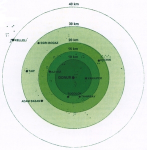
The Gonur-centric system according to Sarianidi (2005).
One has the impression, even if he affirms that "... the spatial organisational model proposed by Masimov in 1981 has been decisively superseded today" (ibid), the basic picture remains more or less that proposed by Masimov and Sarianidi. It should be borne in mind that in all the theories elaborated up to now, the extension of the sites has been considered as directly proportional to their importance. This is a theory that needs to be demonstrated since, whilst some sites have been reconstructed on top of' pre-existing ones, others were abandoned and reconstructed nearby, thus occupying a larger area, but in completely different periods. To this end, S. Salvatori correctly observes that: "This interpretation is, in reality, the result of a chronological telescoping of the settlement system by the first explorers of the area. The settlement of Gonur 1, for example, consists of two mound formations, one larger to the north, and a smaller one to the south. The northern mound has been clearly ascribed to the Namazga V period (Bronze Age), while the southern one, apart from the lowest level, can be dated to the following Namazga V period (Late Bronze Age) " (ibid.). Moreover, it should be observed that the presumed 'extension = importance of site' idea is to a considerable degree the result of surface observations which are often limited to what can be seen now, without considering the complex workings of external modifications which have taken place over the last 5,000 years.
Let us take as an example the complex of Adj Kui. According to Masimov's surveys, redrawn and updated by the AMMD, AKI covered an area of 3.5 hectares and AK9 0.98 hectares. However, after the interventions of cleaning, sounding und excavation which we have carried out, the area covered by the site has proved to be much larger: AKI at least 14 hectares, AK9 about 6.25 hectares and the necropolis, situated between the two entities about 10 hectares. The whole therefore covers an area of at least 30 hectares, a figure very close to that of Altyn-depe, which has been calculated at 26 hectares. How is it therefore possible to put forward a hierarchy of sites exposed for millennia to profound external modifications by taking just surface area as the yardstick? In the wake of the hypothesis proposed by Sarianidi regarding the hierarchy of the Margian sites, even if at a more complex and sophisticated level, there would seem to have been a tendency towards elaboration of data collected by the AMMD which, on applying the Thiessel polygon model to the Margian case, could demonstrate the existence "of a settlement system hierarchically organised with Gonur North at it centre" around which " the secondary sites spread out like a sunburst, in a coherent latticework and at modular distances" (SALVATORI: ib.)But is this not Sarianidi's hypothesis? Let us then consider the idea of a Margian "kingdom " with a "capital ", Gonur, around which gravitated the satellite sites, with the Thiessen polygonal latticework taken as demonstrating definite proof. It is worth remembering that the 'Thiessen polygon' enjoyed a certain vogue in classical archaeology in the eighties, when the hierarchy of sites distributed throughout a given territory, yet with indefinable boundaries, needed to be "demonstrated ". However, this method was quickly shelved.
The reasons why it was unacceptable have been spelled out by Claudio Cerreti, professor of Political and Economic Geography at the University of Rome and national co-ordinator of the Italian Centre for HistoricalGeographical Studies: The Thiessen polygons were employed in geography (economic, urban) and in archaeology some decades ago. However, like other geometric-graphic systems, they were subsequently abandoned because they were unconvincing. Quite simply, in fact, nearly all those methods which postulate a "too simple" solution have been abandoned because they could not work. In geometry, the "too simple" condition is that the space is isomorphic. 'This does not, however, reflect the reality of land surface, where each point possesses an unrepeatable "value" of its own and where each surface, however irregular, includes different elements than any other surface, even if equal in area.
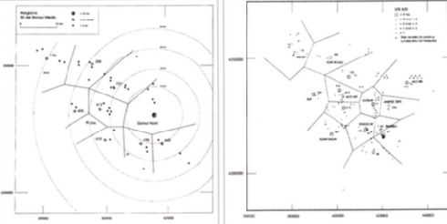
The Gonur-centric system according to Salvatori (2004) - Thiessen's polygonal network calculated on Gonur Sud (IsIAO 1998).
This kind of method continues to be used for approximate calculations and, in certain conditions, it can make sense: it simplifies reality and allows one to formulate certain arguments, even if somewhat "theoretical". But to claim that they can explain how those things work, thanks to these methods, has by now, I believe, been sidelined. To conclude: any analysis of this type might have a preliminary use for comparison purposes with respect to a situation which, step by step, can be documented. It is a little like discussing the values of (medium) density of population and then verifying in certain areas how far it moves away from the medium. It is not completely senseless, but one should always bear in mind that it is rather "rarefied". If, to all this, we add that the entire Margian area examined topographically up to now forarchaeological purposes is 30% covered by dunes (CREMASCHI 1998:19), we must conclude that, more than fifty years after the first researches, it is still not possible to agree on a picture of the Bronze Age in Margiana. The architectonic monumentality of the fortified citadels is by no means free of doubts and not everyone accepts a picture of cultural interrelationships in which now the civilisation of the Indus Valley is considered paramount, now the Elamite and Trans-Elamite, now the Mycenean, now that of the nomads of the Asiatic steppes. Still others do not agree on hypotheses dealing with the peopling of the region, which change either according to virtually elementary mechanisms (simple migration ftom the piedmont area of the Kopet Dagh) or to complex systems revolving around the theme of proto-Zoroastrianism, or to even more complex guestions of proto-Aryan peoples.
Finally, even regarding the validity of the chronology that we have adopted up to now, this would seem to be in line with Namazga IVV- VI sequences, yet there still remain doubts and perplexities. So much so that the French mission directed by Olivier Lecomte at Ulugdepe is working on a review of this problem. As has been noted, we are confronted with a general picture which has not been greatly benefited even by the most recent studies, which are unfortunately limited to studving data from the surface. Therefore, as already stated, the imperative remains the same: excavate in order to understand.
(ibid., p. 30-37)
Source: Rossi Osmida, G.: Adji Kui Oasis. Vol.I: The Citadel of the Figurines.Venice: Il Punto Edizioni 2007.